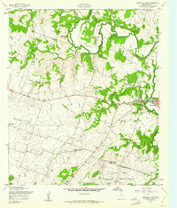
1957 Map of Gatesville West
USGS Topo · Published 1961About this map
The Leon River meanders across this central Texas landscape, shaping the development of Gatesville and its surrounding rural community during the late 1950s. The map captures a transition in land use, where traditional family landmarks like the Hemmeline Cem and Standlee Chapel sit alongside the expanding Fort Hood Military Reservation to the south. An Old Railroad Grade hints at earlier transportation networks that once linked these small settlements.
Find a feature on this map
19 named features on this map. Tap any name to fly to it.
Don’t see what you’re looking for? This feature index may not catch every label — zoom into the map to look around manually.
Map Details
Editions of this 1957 Gatesville West Map
This is the sole edition of this map. No revisions or reprints were ever made.
Other maps of this area

1888 · Meridian
USGS Topo · 1:125,000

1894 · Meridian
USGS Topo · 1:125,000

1894 · Gatesville
USGS Topo · 1:125,000

1947 · Purmela
USGS Topo · 1:62,500

1947 · Gatesville West
USGS Topo · 1:24,000

1947 · Pidcoke
USGS Topo · 1:24,000

1947 · North Fort Hood
USGS Topo · 1:24,000

1947 · Purmela
USGS Topo · 1:24,000

1947 · Gatesville East
USGS Topo · 1:24,000

1947 · Shell Mountains
USGS Topo · 1:24,000