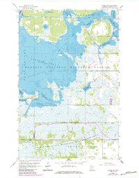
1962 Map of Gatzke SW
USGS Topo · Published 1984About this map
Agassiz National Wildlife Refuge dominates this Marshall County landscape, revealing an intricate system of managed wetlands and pools within the Whiteford, East Valley, and Grand Plain townships. The map documents a highly engineered environment where the Mud River and Lost River are diverted and pooled through features like Agassiz Pool and the tiered Upper, Middle, and Lower CCC Pools. This 1962 survey, updated with 1982 aerial data, shows the concentration of management infrastructure near the Refuge Headquarters, including a Lookout Tower and Green Stump Pool. South of the federal lands, the Elm Lake State Wildlife Management Area extends the conservation footprint, while the presence of Judicial Ditch No 11 underscores the region's history of complex water management for both drainage and habitat preservation.
Find a feature on this map
30 named features on this map. Tap any name to fly to it.
Don’t see what you’re looking for? This feature index may not catch every label — zoom into the map to look around manually.
Map Details
Editions of this 1962 Gatzke SW Map
2 editions found
Other maps of this area

1918 · Rollis
USGS Topo · 1:62,500

1918 · Middle River
USGS Topo · 1:62,500

1943 · Rollis
USGS Topo · 1:62,500

1943 · Thief River Falls
USGS Topo · 1:62,500

1952 · Thief River Falls
USGS Topo · 1:250,000

1954 · Roseau
USGS Topo · 1:250,000

1956 · Thief River Falls
USGS Topo · 1:250,000

1957 · Roseau
USGS Topo · 1:250,000

1957 · Thief River Falls
USGS Topo · 1:250,000

1958 · Roseau
USGS Topo · 1:250,000