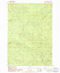
1986 Map of Gawley Creek
USGS Topo · Published 1986About this map
Santiam State Forest dominates this landscape in the mid-1980s, where the boundary between Clackamas and Marion counties follows the high ridgelines of Gawley Ridge. The terrain is defined by a dense network of timber resources and water management, visible in the numerous Quarry and Borrow Pit sites scattered near Table Rock Road. The northern portion of the map follows the winding course of the Molalla River, which gathers waters from numerous tributaries like Bear Creek and Horse Creek.
Find a feature on this map
47 named features on this map. Tap any name to fly to it.
Don’t see what you’re looking for? This feature index may not catch every label — zoom into the map to look around manually.
Map Details
Editions of this 1986 Gawley Creek Map
This is the sole edition of this map. No revisions or reprints were ever made.
Other maps of this area

1916 · Estacada
USGS Topo · 1:125,000

1929 · Mill City
USGS Topo · 1:125,000

1939 · Molalla
USGS Topo · 1:62,500

1940 · Molalla
USGS Topo · 1:62,500

1948 · Vancouver
USGS Topo · 1:250,000

1950 · Vancouver
USGS Topo · 1:250,000

1950 · Vancouver
USGS Topo · 1:250,000

1951 · Lyons
USGS Topo · 1:62,500

1953 · Salem
USGS Topo · 1:250,000

1954 · Salem
USGS Topo · 1:250,000