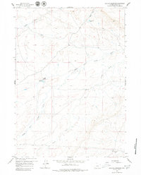
1959 Map of Gaylord Reservoir
USGS Topo · Published 1979About this map
Wyatt Ranch and Davidson Ranch anchor this mid-century survey of the high plains in Natrona County, providing a clear view of ranching infrastructure at a time when many remote outposts were already noted as abandoned. The landscape is defined by the drainage systems of the Middle Fork Casper Creek and Coyote Creek, which snake through the varied terrain toward the Gaylord Reservoir. These water sources, along with Wallace Creek and Wyatt Draw, were essential for the cattle operations and homesteads like the Morton Ranch that persisted in this environment. The presence of a significant Pipeline cutting across the southern sections illustrates the integration of industrial energy transport into the traditional grazing lands of central Wyoming during the late 1950s.
Find a feature on this map
10 named features on this map. Tap any name to fly to it.
Don’t see what you’re looking for? This feature index may not catch every label — zoom into the map to look around manually.
Map Details
Editions of this 1959 Gaylord Reservoir Map
2 editions found
Other maps of this area

1951 · Pine Mountain SW
USGS Topo · 1:24,000

1951 · Square Top Butte
USGS Topo · 1:24,000

1952 · Waltman
USGS Topo · 1:24,000

1955 · Arminto
USGS Topo · 1:250,000

1955 · Casper
USGS Topo · 1:250,000

1958 · Casper
USGS Topo · 1:250,000

1958 · Arminto
USGS Topo · 1:250,000

1959 · Gaylord Reservoir
USGS Topo · 1:24,000

1959 · Eightmile Draw
USGS Topo · 1:24,000

1959 · Broad Mesa
USGS Topo · 1:24,000