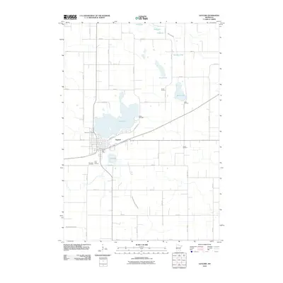
2010 Map of Gaylord
USGS Topo · Published 2010About this map
Gaylord serves as the central hub of this prairie landscape, where the grid of city streets meets the natural curves of Titlow Lake and Mud Lake. The 2010 survey highlights a town well-equipped with civic infrastructure, including the Gaylord Post Office and the Titlow Lake Dam. Beyond the residential center, the surrounding agricultural land is dotted with several family-named burial grounds like Altnow Cemetery, Beatty Cemetery, and Gasow Cemetery, which offer valuable points of reference for local historians and genealogists. Water management is a defining characteristic of this terrain, from the natural flow of High Island Creek and the Middle Branch Rush River to the engineered paths of County Ditch Number Forty-nine. Smaller water bodies such as Kirby Lake, Duff Lake, and Weimann Lake further illustrate the glaciated hydrology of this Sibley County region.
Find a feature on this map
33 named features on this map. Tap any name to fly to it.
Don’t see what you’re looking for? This feature index may not catch every label — zoom into the map to look around manually.
Map Details
Editions of this 2010 Gaylord Map
This is the sole edition of this map. No revisions or reprints were ever made.
Other maps of this area

1953 · New Ulm
USGS Topo · 1:250,000

1957 · New Ulm
USGS Topo · 1:250,000

1958 · New Ulm
USGS Topo · 1:250,000

1958 · Gaylord
USGS Topo · 1:62,500

1958 · Winthrop
USGS Topo · 1:62,500

1964 · Bernadotte
USGS Topo · 1:24,000

1965 · Norseland
USGS Topo · 1:24,000

1965 · New Sweden
USGS Topo · 1:24,000

1967 · New Ulm
USGS Topo · 1:250,000
1982 · Gaylord
USGS Topo · 1:24,000