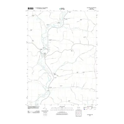
2010 Map of Gays Mills
USGS Topo · Published 2010About this map
The Kickapoo River meanders through the heart of this Driftless Area landscape, anchoring the settlements of Gays Mills, Bell Center, and Petersburg. The terrain is defined by a series of sharp ridges and deep hollows, including Maple Ridge, Larsen Ridge, and Dellamater Hollow, which have long shaped the agricultural and transit patterns of Crawford County. This 2010 survey reflects a rural community deeply tied to its geography, where narrow valley roads like W River Rd and County Hwy Rd S connect small population centers. Family and local history are preserved across the quadrangle in several burial grounds, such as Whiteaker Cemetery and Crow Hollow Cemetery. Near the northern border, the Lourie G9297 Dam represents one of the few instances of water management along the typically wild river corridor. The map serves as a record of the area's intricate drainage system, tracing tributaries like Tainter Creek, Bear Creek, and Sand Creek as they descend from the high ridges into the main valley.
Find a feature on this map
66 named features on this map. Tap any name to fly to it.
Don’t see what you’re looking for? This feature index may not catch every label — zoom into the map to look around manually.
Map Details
Editions of this 2010 Gays Mills Map
This is the sole edition of this map. No revisions or reprints were ever made.
Other maps of this area

1924 · Gays Mills
USGS Topo · 1:62,500

1926 · Gays Mills
USGS Topo · 1:62,500

1926 · Wauzeka
USGS Topo · 1:62,500

1933 · Boaz
USGS Topo · 1:62,500

1933 · Boscobel
USGS Topo · 1:62,500

1958 · La Crosse
USGS Topo · 1:250,000

1961 · La Crosse
USGS Topo · 1:250,000

1965 · La Crosse
USGS Topo · 1:250,000
1966 · Gays Mills
USGS Topo · 1:62,500

1966 · Boaz
USGS Topo · 1:62,500