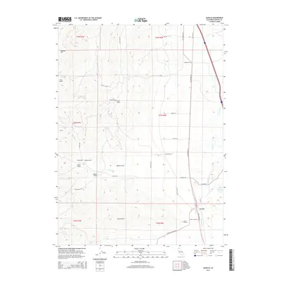
2015 Map of Gazelle
USGS Topo · Published 2015About this map
Gazelle occupies the southeastern valley floor of this Siskiyou County landscape, where the flatlands meet the rising slopes of Antelope Mtn and Bonnet Rock. This 2015 survey illustrates a rural infrastructure defined by long-established family names and natural drainages. Local heritage is centered near the main settlement at the Foulke Cemetery and Gazelle Cemetery, with the town serving as a nexus for routes like Gazelle Callahan Rd and Old Highway 99 S. The terrain is deeply incised by numerous gulches, including Cram Gulch, Winters Gulch, and Stoner Gulch, which feed into the valley toward Willow Cr and the waters of Big Lake. The map details a network of local lanes such as Timmons Rd and Pythian Cave Rd that provide access to the various gulches and ridges of the surrounding high country.
Find a feature on this map
36 named features on this map. Tap any name to fly to it.
Don’t see what you’re looking for? This feature index may not catch every label — zoom into the map to look around manually.
Map Details
Editions of this 2015 Gazelle Map
This is the sole edition of this map. No revisions or reprints were ever made.
Other maps of this area

1886 · Shasta
USGS Topo · 1:250,000

1894 · Shasta
USGS Topo · 1:250,000

1921 · Shasta Valley Sheet No 7
USGS Topo · 1:24,000

1921 · Shasta Valley Sheet No 1
USGS Topo · 1:24,000

1921 · Shasta Valley Sheet No 6
USGS Topo · 1:24,000

1921 · Shasta Valley Sheet No 2
USGS Topo · 1:24,000

1922 · Shasta Valley Sheet No 1 S
USGS Topo · 1:24,000

1922 · Shasta Valley Sheet No 3 S
USGS Topo · 1:24,000
1922 · Shasta Valley Sheet No 8
USGS Topo · 1:24,000

1923 · Sawyers Bar
USGS Topo · 1:125,000