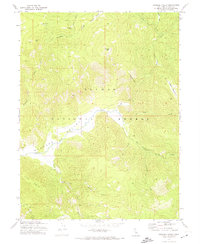
1972 Map of Genesee Valley
USGS Topo · Published 1974About this map
The Genesee Valley floor is the focal point of this 1972 topographical survey, revealing a landscape defined by the confluence of Indian Creek and its mountain tributaries. The small settlement of Genesee sits at the western edge of the valley, while the surrounding Plumas National Forest contains significant evidence of the region’s extractive history. Resource extraction is prominent throughout the terrain, from the Beardsley Mine in the north to the Walker Mine and unnamed Mines located along Ward Creek. Historical transit through the steep drainages is marked by features like the Flournoy Bridge and Dixon Bridge crossing Last Chance Creek and Red Clover Creek. From the high peaks of Kessler Peak and Wheeler Peak down to the unusual terrain of Elephants Playground, the map provides a detailed view of the infrastructure supporting both timber and mineral interests in the Sierra Nevada.
Find a feature on this map
37 named features on this map. Tap any name to fly to it.
Don’t see what you’re looking for? This feature index may not catch every label — zoom into the map to look around manually.
Map Details
Editions of this 1972 Genesee Valley Map
This is the sole edition of this map. No revisions or reprints were ever made.
Other maps of this area

1886 · Honey Lake
USGS Topo · 1:250,000

1891 · Downieville
USGS Topo · 1:125,000

1891 · Honey Lake
USGS Topo · 1:250,000

1893 · Honey Lake
USGS Topo · 1:250,000

1893 · Downieville
USGS Topo · 1:125,000

1895 · Downieville
USGS Topo · 1:125,000

1896 · Downieville
USGS Topo · 1:125,000

1897 · Downieville
USGS Topo · 1:125,000

1937 · Blairsden
USGS Topo · 1:48,000

1943 · Blairsden
USGS Topo · 1:62,500