
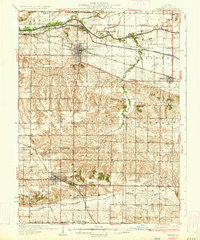
1934 Map of Geneseo
USGS Topo · Published 1934About this map
The agrarian heart of Henry County is meticulously detailed here, centered on the hub of Geneseo and the county seat at Cambridge. This landscape is defined by its sophisticated drainage and transport networks, including the Mississippi Canal and its associated infrastructure like Lock No 25 and Lock No 24. The Chicago Rock Island and Pacific railroad bisects the northern townships, following the natural corridor created by the Green River.
Find a feature on this map
72 named features on this map. Tap any name to fly to it.
Don’t see what you’re looking for? This feature index may not catch every label — zoom into the map to look around manually.
Map Details
Editions of this 1934 Geneseo Map
2 editions found
Other maps of this area

1892 · Leclaire
USGS Topo · 1:62,500

1893 · Leclaire
USGS Topo · 1:62,500

1899 · Clinton
USGS Topo · 1:125,000

1929 · Annawan
USGS Topo · 1:62,500

1931 · Galva
USGS Topo · 1:48,000

1932 · Prophetstown
USGS Topo · 1:48,000

1932 · Annawan
USGS Topo · 1:62,500

1936 · Prophetstown
USGS Topo · 1:62,500

1937 · Orion
USGS Topo · 1:62,500

1940 · Galva
USGS Topo · 1:62,500