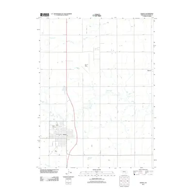
2011 Map of Geneva
USGS Topo · Published 2011About this map
Geneva serves as the focal point of this Fillmore County landscape, shown here at the start of the 2010s with its established grid of streets including S 6th St and E St. The area maintains its agricultural character, defined by a rectilinear network of county roads like Road 15 and Road I that separate vast tracts of farmland. Aviation history is visible on the periphery, most notably the Fairmont State Airfield to the north and the smaller Docs Airport south of the city. Waterways such as Turkey Creek and Indian Creek provide the only natural deviations from the strict surveying lines, meandering through the prairie. Local institutions like the Fillmore County Fairgrounds, the Geneva Post Office, and the Geneva Cemetery anchor the community, while the small settlement of Burress sits along the eastern edge of the quadrangle.
Find a feature on this map
32 named features on this map. Tap any name to fly to it.
Don’t see what you’re looking for? This feature index may not catch every label — zoom into the map to look around manually.
Map Details
Editions of this 2011 Geneva Map
This is the sole edition of this map. No revisions or reprints were ever made.
Other maps of this area

1898 · York
USGS Topo · 1:125,000

1898 · Hebron
USGS Topo · 1:125,000

1899 · York
USGS Topo · 1:125,000

1955 · Lincoln
USGS Topo · 1:250,000

1957 · Lincoln
USGS Topo · 1:250,000

1958 · Lincoln
USGS Topo · 1:250,000
1961 · Ohiowa
USGS Topo · 1:24,000
1969 · Geneva
USGS Topo · 1:24,000

1969 · Fairmont
USGS Topo · 1:24,000
1969 · Grafton
USGS Topo · 1:24,000