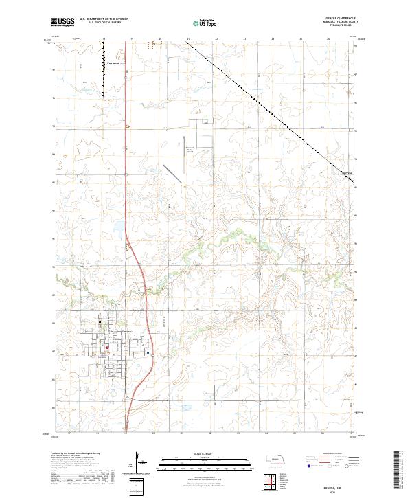
2021 Map of Geneva
USGS Topo · Published 2021About this map
Geneva serves as the focal point of this Fillmore County landscape, where the Fillmore County Courthouse stands as a central civic landmark. The town's grid is meticulously detailed, extending northward toward the Geneva Cem. To the north, the settlement of Fairmont lies along the section lines, while the small community of Burress is situated to the northeast. The surrounding terrain is defined by the meandering courses of Turkey Cr and Indian Cr, which cut through the agricultural plains.
Find a feature on this map
59 named features on this map. Tap any name to fly to it.
Don’t see what you’re looking for? This feature index may not catch every label — zoom into the map to look around manually.
Map Details
Editions of this 2021 Geneva Map
This is the sole edition of this map. No revisions or reprints were ever made.
Other maps of this area

1898 · York
USGS Topo · 1:125,000

1898 · Hebron
USGS Topo · 1:125,000

1899 · York
USGS Topo · 1:125,000

1955 · Lincoln
USGS Topo · 1:250,000

1957 · Lincoln
USGS Topo · 1:250,000

1958 · Lincoln
USGS Topo · 1:250,000
1961 · Ohiowa
USGS Topo · 1:24,000
1969 · Geneva
USGS Topo · 1:24,000

1969 · Fairmont
USGS Topo · 1:24,000
1969 · Grafton
USGS Topo · 1:24,000