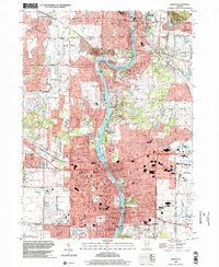
1998 Map of Geneva
USGS Topo · Published 2002About this map
The Fox River corridor serves as the central artery for this late 20th-century landscape, anchoring a dense network of suburban development and preserved greenspace. In St Charles and Geneva, the river is flanked by an extensive collection of protected lands, including Mt St Mary Park and the Leroy Oaks County Forest Preserve. The map documents a mature educational and civic infrastructure, from the Illinois Youth Center (St Charles) to parochial institutions like St Patrick Sch and St Peters Sch.
Find a feature on this map
83 named features on this map. Tap any name to fly to it.
Don’t see what you’re looking for? This feature index may not catch every label — zoom into the map to look around manually.
Map Details
Editions of this 1998 Geneva Map
This is the sole edition of this map. No revisions or reprints were ever made.
Other maps of this area

1908 · Wheaton
USGS Topo · 1:62,500

1923 · Barrington
USGS Topo · 1:62,500

1925 · Elgin
USGS Topo · 1:62,500

1932 · Geneva
USGS Topo · 1:62,500

1935 · Barrington
USGS Topo · 1:62,500

1940 · Elgin
USGS Topo · 1:62,500

1948 · Wheaton
USGS Topo · 1:62,500

1948 · Geneva
USGS Topo · 1:62,500

1949 · Geneva
USGS Topo · 1:24,000

1950 · Aurora North
USGS Topo · 1:24,000