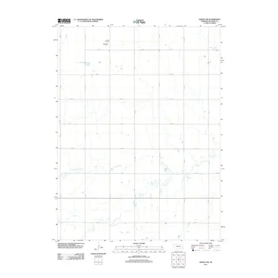
2011 Map of Geneva SW
USGS Topo · Published 2011About this map
Grafton Cemetery and Holy Cross Cemetery sit in the northern reaches of this Fillmore County landscape, serving as significant markers for local genealogical research. The terrain is defined by a precise grid of rural thoroughfares, including Road G and Road 7, which navigate a drainage system led by the North Fork Turkey Creek and the main branch of Turkey Creek. This network of waterways, featuring smaller tributaries like Elk Run and Indian Creek, carves a winding path through the structured agricultural plots. The map captures the organized rural character of the Nebraska plains, where the intersection of straight-line roads and wandering creek beds dictates the placement of homesteads and community landmarks during the early 21st century.
Find a feature on this map
21 named features on this map. Tap any name to fly to it.
Don’t see what you’re looking for? This feature index may not catch every label — zoom into the map to look around manually.
Map Details
Editions of this 2011 Geneva SW Map
This is the sole edition of this map. No revisions or reprints were ever made.
Other maps of this area

1898 · York
USGS Topo · 1:125,000

1898 · Hebron
USGS Topo · 1:125,000

1899 · York
USGS Topo · 1:125,000

1955 · Lincoln
USGS Topo · 1:250,000

1957 · Lincoln
USGS Topo · 1:250,000

1958 · Lincoln
USGS Topo · 1:250,000

1969 · Bixby
USGS Topo · 1:24,000
1969 · Ong
USGS Topo · 1:24,000
1969 · Geneva
USGS Topo · 1:24,000

1969 · Fairmont
USGS Topo · 1:24,000