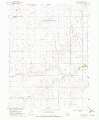
1969 Map of Geneva SW
USGS Topo · Published 1971About this map
The rolling agricultural terrain of Fillmore County in the late 1960s is defined by a rhythmic grid of section lines and the meandering paths of its waterways. Significant conservation areas anchor the northern landscape, including the Morphy Lagoon National Wildlife Management Area and the Wilkins Lagoon National Wildlife Management Area, highlighting the region's importance for migratory waterfowl. The prairie drainage is captured in detail as North Fork Turkey Creek and Turkey Creek cut through the central townships of Bennett and Geneva. Near the northern border at the Grafton Corp Bdy, local history is preserved at the Grafton Cem and Holy Cross Cem, while the township boundaries of Momence, Stanton, and West Blue mark the administrative divisions of this rural Nebraska heartland.
Find a feature on this map
14 named features on this map. Tap any name to fly to it.
Don’t see what you’re looking for? This feature index may not catch every label — zoom into the map to look around manually.
Map Details
Editions of this 1969 Geneva SW Map
This is the sole edition of this map. No revisions or reprints were ever made.
Other maps of this area

1898 · York
USGS Topo · 1:125,000

1898 · Hebron
USGS Topo · 1:125,000

1899 · York
USGS Topo · 1:125,000

1955 · Lincoln
USGS Topo · 1:250,000

1957 · Lincoln
USGS Topo · 1:250,000

1958 · Lincoln
USGS Topo · 1:250,000

1969 · Bixby
USGS Topo · 1:24,000
1969 · Ong
USGS Topo · 1:24,000
1969 · Geneva
USGS Topo · 1:24,000

1969 · Fairmont
USGS Topo · 1:24,000