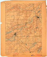
1893 Map of Geneva
USGS Topo · Published 1903About this map
The Lake Geneva region in the 1890s reveals a landscape defined by the intersection of glacial lake basins and an expanding rail network. The village of Geneva sits prominently on the eastern shore of its namesake lake, while to the northeast, Burlington has emerged as a significant junction where the Wisconsin Central Railroad meets the Fox River. The map captures the transit-heavy character of Walworth and neighboring counties, with the Chicago Milwaukee and St. Paul Railroad cutting across the central terrain through Springfield and Lyons. To the south, smaller water bodies like Pell Lake and Power Lake are mapped alongside the Chicago and Northwestern Railroad corridor, which served specialized stops like Twin Lake Station. This survey provides a look at the early settlement pattern of southern Wisconsin before the intensive 20th-century development of the lakeside resorts.
Find a feature on this map
37 named features on this map. Tap any name to fly to it.
Don’t see what you’re looking for? This feature index may not catch every label — zoom into the map to look around manually.
Map Details
Editions of this 1893 Geneva Map
2 editions found
Other maps of this area

1891 · Muskego
USGS Topo · 1:62,500

1892 · Whitewater
USGS Topo · 1:62,500

1892 · Eagle
USGS Topo · 1:62,500

1893 · Delavan
USGS Topo · 1:62,500

1893 · Whitewater
USGS Topo · 1:62,500

1893 · Silver Lake
USGS Topo · 1:62,500

1893 · Geneva
USGS Topo · 1:62,500

1894 · Eagle
USGS Topo · 1:62,500

1897 · Eagle
USGS Topo · 1:62,500

1901 · Muskego
USGS Topo · 1:62,500