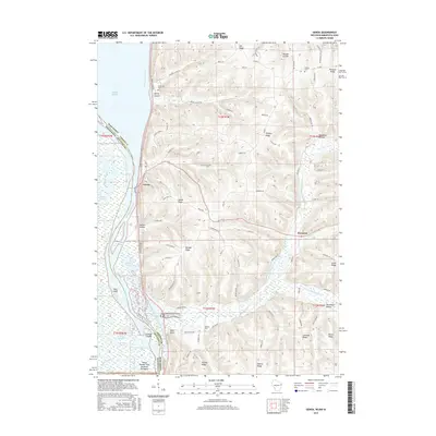
2015 Map of Genoa
USGS Topo · Published 2015About this map
Genoa sits prominently along the Mississippi River in this detailed 2015 study of the river valley and its high coulee country. The landscape is defined by the complex hydrography of Pool 8, where the main channel is flanked by a network of backwaters including Zaboli Lake, Pickerel Slough, and Waller Lakes. This environment transition sharply into the steep ridges and narrow valleys of Vernon County, where labels such as Italian Hollow and Venner Hollow suggest the legacy of early settlement and land use. Away from the river, the uplands are dominated by high points like Oak Ridge and Victory Ridge, with small rural communities like Romance situated along the winding Cox Cr. Local history is anchored by several burial sites, including Riverside Cem, Krause Cem, and the German Cem, which dot the landscape from the river bluffs to the interior valleys.
Find a feature on this map
95 named features on this map. Tap any name to fly to it.
Don’t see what you’re looking for? This feature index may not catch every label — zoom into the map to look around manually.
Map Details
Editions of this 2015 Genoa Map
This is the sole edition of this map. No revisions or reprints were ever made.
Other maps of this area

1903 · Waukon
USGS Topo · 1:125,000

1926 · Stoddard
USGS Topo · 1:62,500

1929 · Ferryville
USGS Topo · 1:62,500

1932 · Ferryville
USGS Topo · 1:62,500

1956 · Brownsville
USGS Topo · 1:62,500

1958 · La Crosse
USGS Topo · 1:250,000

1961 · La Crosse
USGS Topo · 1:250,000

1965 · La Crosse
USGS Topo · 1:250,000
1965 · Stoddard
USGS Topo · 1:62,500

1966 · Ferryville
USGS Topo · 1:62,500