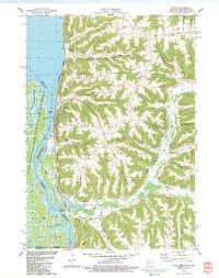
1983 Map of Genoa
USGS Topo · Published 1983About this map
The Mississippi River dominates this early 1980s landscape, bordering the village of Genoa where the Burlington Northern railroad runs parallel to the water. The river's complex ecology is preserved within the Upper Mississippi River Wild Life and Fish Refuge, featuring a labyrinth of backwaters such as Crooked Creek Slough, Thief Slough, and Zabolio Lake. Industrial and navigational infrastructure is prominent, including the massive Lock and Dam No 8 and a riverside Powerplant. Inland, the terrain rises sharply into a series of ridges and hollows, such as Hickory Ridge and Italian Hollow, which are marked by numerous quarries and small family-named cemeteries like German Cem and Krause Cem. The confluence of the Bad Axe River and the Mississippi provides a glimpse into the regional drainage patterns and the established recreational sites at Bad Axe Landing.
Find a feature on this map
72 named features on this map. Tap any name to fly to it.
Don’t see what you’re looking for? This feature index may not catch every label — zoom into the map to look around manually.
Map Details
Editions of this 1983 Genoa Map
This is the sole edition of this map. No revisions or reprints were ever made.
Other maps of this area

1903 · Waukon
USGS Topo · 1:125,000

1926 · Stoddard
USGS Topo · 1:62,500

1929 · Ferryville
USGS Topo · 1:62,500

1932 · Ferryville
USGS Topo · 1:62,500

1956 · Brownsville
USGS Topo · 1:62,500

1958 · La Crosse
USGS Topo · 1:250,000

1961 · La Crosse
USGS Topo · 1:250,000

1965 · La Crosse
USGS Topo · 1:250,000
1965 · Stoddard
USGS Topo · 1:62,500

1966 · Ferryville
USGS Topo · 1:62,500