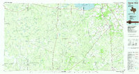
1985 Map of George West
USGS Topo · Published 1985About this map
George West and the surrounding brush country of South Texas are shown during a period of significant hydrological and industrial transition. At the confluence of the Atascosa River, Frio River, and Nueces River, the Choke Canyon Reservoir is depicted while still under construction, a project that fundamentally altered the local geography. The landscape is a patchwork of ranching land and intensive energy extraction, marked by numerous named petroleum zones including the Claunch Oil Field, Ezzell Oil Field, and the Clay West Oil Field.
Find a feature on this map
129 named features on this map. Tap any name to fly to it.
Don’t see what you’re looking for? This feature index may not catch every label — zoom into the map to look around manually.
Map Details
Editions of this 1985 George West Map
2 editions found
Other maps of this area

1920 · Mikeska
USGS Topo · 1:125,000

1920 · San Diego
USGS Topo · 1:62,500

1925 · Oakville No. 4
USGS Topo · 1:48,000

1925 · Mathis No. 2
USGS Topo · 1:48,000

1925 · Simmons No. 1
USGS Topo · 1:48,000

1925 · Tilden No. 1
USGS Topo · 1:48,000

1925 · Mathis No. 3
USGS Topo · 1:48,000

1925 · Crowther No. 3
USGS Topo · 1:48,000

1925 · Simmons No. 2
USGS Topo · 1:48,000

1927 · Mathis
USGS Topo · 1:62,500