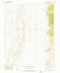
1971 Map of Georges Canyon Rim SE
USGS Topo · Published 1974About this map
West Stone Cabin Valley and East Stone Cabin Valley dominate this Great Basin landscape, divided by a north-south ridge line that defines the local drainage. Water is sparse here, with Willow Creek providing a focal point for the western valley. This 1971 survey captures the area during a period of mineral exploration and land management, indicated by the presence of a Drill Hole and an old Kiln located near the mouth of a Canyon in the northeast. The infrastructure is minimal, consisting of a solitary Jeep Trail that traverses the high desert terrain. The map provides a look at the township and range system in action, with the boundary between T. 6 N. and T. 5 N. clearly delineated across the valley floors.
Find a feature on this map
8 named features on this map. Tap any name to fly to it.
Don’t see what you’re looking for? This feature index may not catch every label — zoom into the map to look around manually.
Map Details
Editions of this 1971 Georges Canyon Rim SE Map
This is the sole edition of this map. No revisions or reprints were ever made.
Other maps of this area

1956 · Tonopah
USGS Topo · 1:250,000

1959 · Tonopah
USGS Topo · 1:250,000

1962 · Tonopah
USGS Topo · 1:250,000

1968 · Tybo
USGS Topo · 1:62,500

1968 · Warm Springs
USGS Topo · 1:62,500
1968 · Warm Springs NW
USGS Topo · 1:24,000
1968 · Flagstaff Mtn.
USGS Topo · 1:24,000
1968 · Tybo
USGS Topo · 1:24,000
1971 · McIntyre Summit
USGS Topo · 1:24,000
1971 · Georges Canyon Rim
USGS Topo · 1:24,000