
1971 Map of Georgetown Lake
USGS Topo · Published 1973About this map
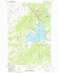
Georgetown Lake sits at the center of this high-elevation landscape within the Deerlodge National Forest, straddling the border between Granite and Deer Lodge counties. The map details a sophisticated water management and industrial network supporting the local area, including the Flint Creek Dam, an Aqueduct, and a Penstock leading to a Powerplant. This infrastructure, alongside the Pumping Sta, suggests the vital role of the lake in regional hydroelectric and irrigation systems during the early 1970s.
Find a feature on this map
41 named features on this map. Tap any name to fly to it.
Don’t see what you’re looking for? This feature index may not catch every label — zoom into the map to look around manually.
Map Details
Editions of this 1971 Georgetown Lake Map
2 editions found
Other maps of this area

1908 · Philipsburg
USGS Topo · 1:125,000

1947 · Butte
USGS Topo · 1:250,000

1958 · Butte
USGS Topo · 1:250,000

1960 · Butte
USGS Topo · 1:250,000

1962 · Butte
USGS Topo · 1:250,000

1971 · Antelope Creek
USGS Topo · 1:24,000

1971 · Potato Lakes
USGS Topo · 1:24,000
1971 · Philipsburg
USGS Topo · 1:24,000
1971 · Fred Burr Lake
USGS Topo · 1:24,000
1971 · Carpp Ridge
USGS Topo · 1:24,000