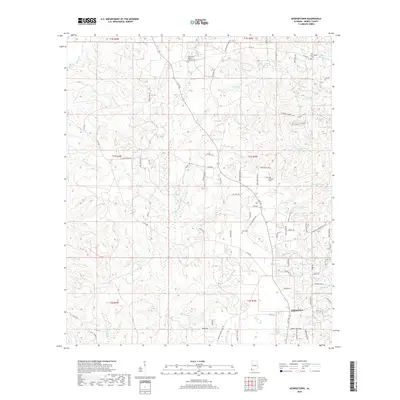
2018 Map of Georgetown
USGS Topo · Published 2018About this map
Georgetown anchors this 2018 survey of Mobile County, where the landscape is defined by an intricate network of creeks and branches. The terrain is marked by significant hydrological features including Puppy Cr and Sand Hill Cr, which drain a region characterized by numerous small ridges and valleys. Genealogists will find several burial sites preserved on the landscape, notably the Fellowship Baptist Church Cem and the Old Providence Cem near the northern boundary.
Find a feature on this map
86 named features on this map. Tap any name to fly to it.
Don’t see what you’re looking for? This feature index may not catch every label — zoom into the map to look around manually.
Map Details
Editions of this 2018 Georgetown Map
This is the sole edition of this map. No revisions or reprints were ever made.
Other maps of this area
1941 · Creola
USGS Topo · 1:62,500
1942 · Kushla
USGS Topo · 1:31,680
1942 · Deer Park
USGS Topo · 1:62,500
1942 · Wilmer
USGS Topo · 1:62,500
1943 · Creola
USGS Topo · 1:62,500
1943 · Deer Park
USGS Topo · 1:62,500
1943 · Citronelle
USGS Topo · 1:62,500
1944 · Wilmer
USGS Topo · 1:62,500
1946 · Citronelle
USGS Topo · 1:62,500
1953 · Kushla
USGS Topo · 1:24,000