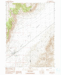
1990 Map of Gerlach
USGS Topo · Published 1990About this map
Gerlach sits at the precipice of the Black Rock Desert, serving as a vital rail point for the Western Pacific line. This arid landscape is defined by the sharp transition from the towering peaks of the Granite Range to the vast alkali flats. Geothermal activity is a prominent local characteristic, marked by the presence of Great Boiling Spring just north of the town center. The settlement includes essential desert infrastructure, from the local Cem and Landing Strip to numerous Tanks and a Well system. In the northern reaches, the terrain climbs toward Bowen Canyon and Granite Basin, while the eastern portion of the sheet is dominated by the rugged slopes of the Selenite Range. The map also delineates the jurisdictional boundary between Washoe and Pershing counties, crossing the desert floor.
Find a feature on this map
18 named features on this map. Tap any name to fly to it.
Don’t see what you’re looking for? This feature index may not catch every label — zoom into the map to look around manually.
Map Details
Editions of this 1990 Gerlach Map
This is the sole edition of this map. No revisions or reprints were ever made.
Other maps of this area

1886 · Granite Range
USGS Topo · 1:250,000

1894 · Granite Range
USGS Topo · 1:250,000

1955 · Lovelock
USGS Topo · 1:250,000

1959 · Lovelock
USGS Topo · 1:250,000

1964 · Gerlach
USGS Topo · 1:62,500

1980 · Dry Mountain NW
USGS Topo · 1:24,000
1980 · The Banjo
USGS Topo · 1:24,000

1980 · Tenmile
USGS Topo · 1:24,000
1980 · Trego
USGS Topo · 1:24,000
1980 · Hualapai Flat South
USGS Topo · 1:24,000