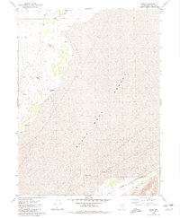
1980 Map of Trego
USGS Topo · Published 1981About this map
The vast, arid expanse of the Black Rock Desert dominates this Pershing County landscape, where survival hinges on the location of scarce water sources. Isolated points like Lost Spr, Flowing Wells, and the seasonally absent Coyote Spring (Dry) highlight the challenging environment for early travelers and miners. Along the base of the mountains, mineral extraction is evidenced by the Cassidy Mine and a lone Prospect, reflecting the region's intermittent mining history.
Find a feature on this map
12 named features on this map. Tap any name to fly to it.
Don’t see what you’re looking for? This feature index may not catch every label — zoom into the map to look around manually.
Map Details
Editions of this 1980 Trego Map
This is the sole edition of this map. No revisions or reprints were ever made.
Other maps of this area

1886 · Granite Range
USGS Topo · 1:250,000

1894 · Granite Range
USGS Topo · 1:250,000

1955 · Lovelock
USGS Topo · 1:250,000

1959 · Lovelock
USGS Topo · 1:250,000

1964 · Gerlach
USGS Topo · 1:62,500

1980 · Dry Mountain NW
USGS Topo · 1:24,000
1980 · Black Rock Point West
USGS Topo · 1:24,000
1980 · Trego Hot Spring
USGS Topo · 1:24,000

1980 · Dry Mountain
USGS Topo · 1:24,000
1980 · Hualapai Flat North
USGS Topo · 1:24,000