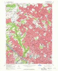
1967 Map of Germantown
USGS Topo · Published 1969About this map
Wissahickon Creek winds through the heart of this landscape, carving a green corridor that separates the dense residential grids of Germantown and Mt Airy from the suburban developments of Whitemarsh and Springfield. The late 1960s urban fabric is defined by a heavy concentration of institutional landmarks, including La Salle College, Germantown Hospital, and Pennsylvania College of Optometry. This era shows the established dominance of the Penn Central and Reading rail lines, which fostered the growth of commuter enclaves like Chestnut Hill, Jenkintown, and Glenside.
Find a feature on this map
126 named features on this map. Tap any name to fly to it.
Don’t see what you’re looking for? This feature index may not catch every label — zoom into the map to look around manually.
Map Details
Editions of this 1967 Germantown Map
4 editions found
Other maps of this area

1891 · Philadelphia
USGS Topo · 1:62,500

1893 · Germantown
USGS Topo · 1:62,500

1894 · Chester
USGS Topo · 1:62,500

1894 · Philadelphia
USGS Topo · 1:62,500

1894 · Norristown
USGS Topo · 1:62,500

1894 · Germantown
USGS Topo · 1:62,500

1895 · Norristown
USGS Topo · 1:62,500

1896 · Germantown
USGS Topo · 1:62,500

1896 · Philadelphia
USGS Topo · 1:62,500

1896 · Norristown
USGS Topo · 1:62,500
Featured Places
- Philadelphia, PA
- Abington Township, PA
- Cheltenham Township, PA
- Whitemarsh Township, PA
- Glenside, Cheltenham Township