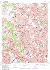
1967 Map of Germantown
USGS Topo · Published 1984About this map
Wissahickon Creek and the Schuylkill River anchor this mid-century look at the densely settled landscape where Northwest Philadelphia meets Montgomery County. The map captures the area's transition from historic townships like Germantown and Roxborough to the burgeoning post-war suburbs of Wyndmoor and Flourtown. Institutional expansion is evident through the footprints of Temple University and Chestnut Hill College, while the Deshler-Morris House stands as a focal point for local heritage. Transportation networks including the Pennsylvania Turnpike and lines for Conrail and Septa underscore the region's role as a vital corridor. Large tracts of green space, such as Fort Washington State Park and the Awbury Arboretum, provide a clear contrast to the expanding industrial and residential grids in Manayunk and Nicetown.
Find a feature on this map
91 named features on this map. Tap any name to fly to it.
Don’t see what you’re looking for? This feature index may not catch every label — zoom into the map to look around manually.
Map Details
Editions of this 1967 Germantown Map
4 editions found
Other maps of this area

1891 · Philadelphia
USGS Topo · 1:62,500

1893 · Germantown
USGS Topo · 1:62,500

1894 · Chester
USGS Topo · 1:62,500

1894 · Philadelphia
USGS Topo · 1:62,500

1894 · Norristown
USGS Topo · 1:62,500

1894 · Germantown
USGS Topo · 1:62,500

1895 · Norristown
USGS Topo · 1:62,500

1896 · Germantown
USGS Topo · 1:62,500

1896 · Philadelphia
USGS Topo · 1:62,500

1896 · Norristown
USGS Topo · 1:62,500
Featured Places
- Philadelphia, PA
- Abington Township, PA
- Cheltenham Township, PA
- Whitemarsh Township, PA
- Glenside, Cheltenham Township