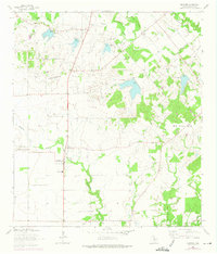
1964 Map of Geronimo
USGS Topo · Published 1975About this map
Geronimo and the surrounding agricultural lands of Guadalupe County are defined by a network of drainage creeks and family landmarks in this mid-century survey. The landscape transitions from the elevated Harborth Hill and Mill Creek Hills toward the lower alluvial plains where Geronimo Creek and Alligator Creek converge. Local history is deeply etched into the terrain through numerous family burial sites, including Zorn Cem, Wade Cem, and Jechow Cem, alongside the San Juan Cem near the central settlement. Education and transit are anchored by the Navarro Sch and the Southern Pacific railroad line cutting through the southeast corner. The presence of several small reservoirs with specific spillway elevations suggests a landscape managed for water control and livestock, while the smaller community of Lauback and the recreational space at Silva Park mark the southern reach of the quadrangle.
Find a feature on this map
19 named features on this map. Tap any name to fly to it.
Don’t see what you’re looking for? This feature index may not catch every label — zoom into the map to look around manually.
Map Details
Editions of this 1964 Geronimo Map
3 editions found
Other maps of this area

1911 · San Marcos
USGS Topo · 1:125,000

1919 · San Marcos
USGS Topo · 1:125,000

1924 · New Braunfels No 4
USGS Topo · 1:48,000

1924 · San Marcos 3-c
USGS Topo · 1:48,000

1924 · San Marcos 3-d
USGS Topo · 1:48,000

1925 · New Braunfels No 1
USGS Topo · 1:48,000

1927 · New Braunfels
USGS Topo · 1:62,500

1929 · Hunter
USGS Topo · 1:62,500

1930 · Seguin
USGS Topo · 1:62,500

1953 · Seguin
USGS Topo · 1:250,000