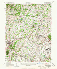
1951 Map of Gettysburg
USGS Topo · Published 1965About this map
Gettysburg and its surrounding Adams County farmlands appear in this mid-century topographic record, showing the landscape just after the second World War. The town center is flanked by the enduring landmarks of the 1863 conflict, including Cemetery Ridge, Seminary Ridge, and the prominent heights of Round Top and Little Round Top. Beyond the battlefield, the map documents a robust rural infrastructure of the 1940s and 50s, characterized by numerous one-room schoolhouses like Victory Sch and Whitcomb View Sch, and local industry represented by Goodintent Mills and the Quarry near Bittinger. The rail network of the Reading and Western Maryland lines remains central to the region's geography, connecting agricultural hubs such as Biglerville and New Oxford. Notable institutional sites like the Hoffman Orphanage and the historic Conewago Chapel anchor the communal landscape of the southern Pennsylvania countryside.
Find a feature on this map
134 named features on this map. Tap any name to fly to it.
Don’t see what you’re looking for? This feature index may not catch every label — zoom into the map to look around manually.
Map Details
Editions of this 1951 Gettysburg Map
3 editions found
Other maps of this area

1904 · Carlisle
USGS Topo · 1:62,500

1905 · Westminster
USGS Topo · 1:62,500

1906 · New Cumberland
USGS Topo · 1:62,500

1908 · Gettysburg
USGS Topo · 1:62,500

1909 · Fairfield
USGS Topo · 1:62,500

1911 · Taneytown
USGS Topo · 1:62,500

1911 · Emmitsburg
USGS Topo · 1:62,500

1919 · Newville
USGS Topo · 1:62,500

1920 · Hanover
USGS Topo · 1:62,500

1922 · Hanover
USGS Topo · 1:62,500