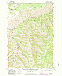
1964 Map of Gibbon
USGS Topo · Published 1983About this map
The Union Pacific railroad line winds through the river valley in this corner of Umatilla County, connecting the small settlement at Gibbon with the wider region. Located at the intersection of the Umatilla Indian Reservation and the Umatilla National Forest, the landscape is defined by the confluence of the Umatilla River and Meacham Creek. To the south of Bonifer, the terrain is dominated by a series of steep topographic features, including the dramatically named Starve-to-Death Ridge and Stumbaugh Ridge.
Find a feature on this map
37 named features on this map. Tap any name to fly to it.
Don’t see what you’re looking for? This feature index may not catch every label — zoom into the map to look around manually.
Map Details
Editions of this 1964 Gibbon Map
2 editions found
Other maps of this area

1953 · Pendleton
USGS Topo · 1:250,000

1956 · Pendleton
USGS Topo · 1:250,000

1963 · Bingham Springs
USGS Topo · 1:24,000

1963 · Blalock Mountain
USGS Topo · 1:24,000

1964 · Thorn Hollow
USGS Topo · 1:24,000

1964 · Athena
USGS Topo · 1:24,000

1964 · Weston Mountain
USGS Topo · 1:24,000

1964 · Duncan
USGS Topo · 1:24,000

1964 · Thimbleberry Mtn
USGS Topo · 1:24,000

1964 · Gibbon
USGS Topo · 1:24,000