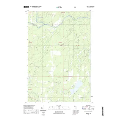
2019 Map of Gibbs City
USGS Topo · Published 2019About this map
Gibbs City and Hazel are the primary points of settlement in this northern Michigan wilderness, situated along the river networks of the Ottawa National Forest. The landscape is dominated by the complex hydrology of the Iron County highlands, where the Paint Wild and Scenic River and its various branches create a corridor of protected waterways. Transport through this timbered area relies on a mix of local routes like Gibbs City Rd and recreational paths such as the Iron Co Drv-6 Snowmobile Trl. To the south, the terrain softens into a lake-rich district featuring Iron Lake, Webb Lake, and Morrison Lake. These water bodies, fed by smaller streams like Autio Cr and Costigan Cr, define the local geography and provide a clear view of the natural drainage patterns that have shaped the development of Bates Township.
Find a feature on this map
43 named features on this map. Tap any name to fly to it.
Don’t see what you’re looking for? This feature index may not catch every label — zoom into the map to look around manually.
Map Details
Editions of this 2019 Gibbs City Map
This is the sole edition of this map. No revisions or reprints were ever made.
Other maps of this area

1895 · Perch Lake
USGS Topo · 1:62,500

1898 · Iron River
USGS Topo · 1:62,500

1944 · Iron River
USGS Topo · 1:24,000

1944 · Gaastra
USGS Topo · 1:24,000

1945 · Gibbs City
USGS Topo · 1:24,000

1945 · Sunset Lake
USGS Topo · 1:24,000

1946 · Iron River
USGS Topo · 1:31,680

1946 · Sunset Lake
USGS Topo · 1:31,680

1946 · Gaastra
USGS Topo · 1:31,680

1946 · Gibbs City
USGS Topo · 1:31,680