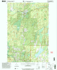
1999 Map of Gibbs City
USGS Topo · Published 2004About this map
Gibbs City and the surrounding wilderness of the Ottawa National Forest define this corner of the Upper Peninsula at the close of the twentieth century. The map documents a landscape deeply shaped by its waterways and reforestation efforts, centered on the Paint River and the South Branch Paint River Forks. Near the river, the Old Atkinson Dam Site and Canoe Access points indicate the transition from early industrial river use to contemporary recreation.
Find a feature on this map
32 named features on this map. Tap any name to fly to it.
Don’t see what you’re looking for? This feature index may not catch every label — zoom into the map to look around manually.
Map Details
Editions of this 1999 Gibbs City Map
This is the sole edition of this map. No revisions or reprints were ever made.
Other maps of this area

1895 · Perch Lake
USGS Topo · 1:62,500

1898 · Iron River
USGS Topo · 1:62,500

1944 · Iron River
USGS Topo · 1:24,000

1944 · Gaastra
USGS Topo · 1:24,000

1945 · Gibbs City
USGS Topo · 1:24,000

1945 · Sunset Lake
USGS Topo · 1:24,000

1946 · Iron River
USGS Topo · 1:31,680

1946 · Sunset Lake
USGS Topo · 1:31,680

1946 · Gaastra
USGS Topo · 1:31,680

1946 · Gibbs City
USGS Topo · 1:31,680