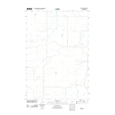
2011 Map of Gibson
USGS Topo · Published 2011About this map
Gibson stands as the primary namesake settlement in this section of Sweet Grass County, situated amidst a landscape defined by an organized grid of rural ranch roads and winding waterways. The drainage patterns of Simmons Creek and the South Fork Big Coulee Creek suggest a terrain of intermittent flow typical of the Montana plains, where water management and road access are central to land use. Transportation through the area is facilitated by a network of thoroughfares including S Barber Rd, S Shawmut Rd, and Kalberg Rd, which provide connection points for local residents and agricultural operations. The inclusion of Sixshooter Creek in the southeast corner further illustrates the importance of these small basins in orienting the high-plains geography of the early 21st century.
Find a feature on this map
11 named features on this map. Tap any name to fly to it.
Don’t see what you’re looking for? This feature index may not catch every label — zoom into the map to look around manually.
Map Details
Editions of this 2011 Gibson Map
This is the sole edition of this map. No revisions or reprints were ever made.
Other maps of this area

1889 · Big Snowy Mountain
USGS Topo · 1:250,000

1891 · Big Timber
USGS Topo · 1:125,000

1892 · Stillwater
USGS Topo · 1:125,000

1893 · Big Snowy Mountain
USGS Topo · 1:250,000

1893 · Big Timber
USGS Topo · 1:125,000

1954 · Billings
USGS Topo · 1:250,000

1954 · Roundup
USGS Topo · 1:250,000

1955 · Russell Gulch
USGS Topo · 1:24,000

1957 · Billings
USGS Topo · 1:250,000
1957 · Sourdough School
USGS Topo · 1:24,000