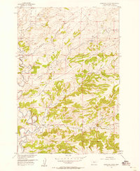
1957 Map of Sourdough School
USGS Topo · Published 1958About this map
Sweet Grass Creek winds through this rural Montana landscape during the mid-1950s, a period when small community schools still anchored the countryside. The geography is defined by a dense network of watercourses, including Sourdough Creek, Cottonwood Creek, and Wildcat Creek, which carve through the terrain as they flow toward the larger Sweet Grass Creek drainage.
Find a feature on this map
11 named features on this map. Tap any name to fly to it.
Don’t see what you’re looking for? This feature index may not catch every label — zoom into the map to look around manually.
Map Details
Editions of this 1957 Sourdough School Map
3 editions found
Other maps of this area

1889 · Big Snowy Mountain
USGS Topo · 1:250,000

1891 · Big Timber
USGS Topo · 1:125,000

1893 · Big Snowy Mountain
USGS Topo · 1:250,000

1893 · Big Timber
USGS Topo · 1:125,000
1954 · Ryan Creek
USGS Topo · 1:24,000

1954 · Billings
USGS Topo · 1:250,000

1954 · Roundup
USGS Topo · 1:250,000

1955 · Greycliff
USGS Topo · 1:24,000

1955 · Stephens Hill
USGS Topo · 1:24,000

1957 · Billings
USGS Topo · 1:250,000