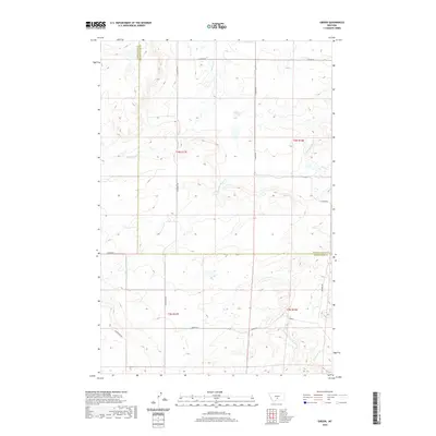
2020 Map of Gibson
USGS Topo · Published 2020About this map
The settlement of Gibson serves as the focal point for this rural landscape where Sweet Grass County and Golden Valley County meet. The terrain is defined by a network of drainage systems, most notably the forks of the Big Coulee Creek, including N Fork Big Coulee Cr and S Fork Big Coulee Cr. To the southeast, Sixshooter Cr cuts through the high ground, while Simmons Cr drains the northwest corner. This area remains primarily characterized by its vast cattle ranching infrastructure and remote road network, with primary access provided by S Barber Rd and S Shawmut Rd. The map illustrates the geometric precision of the Public Land Survey System, dividing the open range into townships such as t3n r18e and t4n r17e, showing a land still largely organized by the original section lines.
Find a feature on this map
18 named features on this map. Tap any name to fly to it.
Don’t see what you’re looking for? This feature index may not catch every label — zoom into the map to look around manually.
Map Details
Editions of this 2020 Gibson Map
This is the sole edition of this map. No revisions or reprints were ever made.
Other maps of this area

1889 · Big Snowy Mountain
USGS Topo · 1:250,000

1891 · Big Timber
USGS Topo · 1:125,000

1892 · Stillwater
USGS Topo · 1:125,000

1893 · Big Snowy Mountain
USGS Topo · 1:250,000

1893 · Big Timber
USGS Topo · 1:125,000

1954 · Billings
USGS Topo · 1:250,000

1954 · Roundup
USGS Topo · 1:250,000

1955 · Russell Gulch
USGS Topo · 1:24,000

1957 · Billings
USGS Topo · 1:250,000
1957 · Sourdough School
USGS Topo · 1:24,000