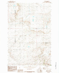
1985 Map of Gibson
USGS Topo · Published 1985About this map
Gibson sits as the primary settlement in this 1985 survey, positioned near the confluence of a complex drainage system in central Montana. The landscape is defined by the various branches of the Big Coulee network, including the North Fork Big Coulee Creek, the South Fork Big Coulee Creek, and the main Big Coulee Creek. These waterways, along with Sixshooter Creek and Simmons Creek, illustrate the hydrologic patterns that shaped the local ranching and agricultural economy. The map also delineates the shared boundary between Sweet Grass County and Golden Valley County, showing how these political lines bisect the drainage basins. This provisional edition provides a clear record of the terrain and rural infrastructure before the turn of the twenty-first century.
Find a feature on this map
9 named features on this map. Tap any name to fly to it.
Don’t see what you’re looking for? This feature index may not catch every label — zoom into the map to look around manually.
Map Details
Editions of this 1985 Gibson Map
This is the sole edition of this map. No revisions or reprints were ever made.
Other maps of this area

1889 · Big Snowy Mountain
USGS Topo · 1:250,000

1891 · Big Timber
USGS Topo · 1:125,000

1892 · Stillwater
USGS Topo · 1:125,000

1893 · Big Snowy Mountain
USGS Topo · 1:250,000

1893 · Big Timber
USGS Topo · 1:125,000

1954 · Billings
USGS Topo · 1:250,000

1954 · Roundup
USGS Topo · 1:250,000

1955 · Russell Gulch
USGS Topo · 1:24,000

1957 · Billings
USGS Topo · 1:250,000
1957 · Sourdough School
USGS Topo · 1:24,000