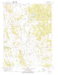
1979 Map of Gifford
USGS Topo · Published 1979About this map
The Chariton River valley and its surrounding timberlands define this 1970s landscape on the border of Adair and Macon Counties. The settlement of Gifford (South Gifford) sits at a crossing point south of the river’s Old Channel, while the village of Yarrow is positioned further north near the banks of Elm Creek. Significant land use patterns are visible, notably the extensive Strip Mines and a large Strip Mine north of Sugar Creek. The creation of Spring Lake and the preservation of the Sugar Creek State Forest highlight a transition toward recreational and conservation-based land management in the late 20th century. Local family history is well-represented through several rural burial grounds, including Canaday Cem and Indian Hill Cem, as well as several country churches like Mt Carmel Ch.
Find a feature on this map
31 named features on this map. Tap any name to fly to it.
Don’t see what you’re looking for? This feature index may not catch every label — zoom into the map to look around manually.
Map Details
Editions of this 1979 Gifford Map
2 editions found
Other maps of this area

1937 · Elmer
USGS Topo · 1:48,000

1938 · Kirksville
USGS Topo · 1:62,500

1940 · Kirksville
USGS Topo · 1:62,500

1942 · Elmer
USGS Topo · 1:62,500

1951 · New Boston
USGS Topo · 1:24,000

1953 · Moberly
USGS Topo · 1:250,000

1954 · Centerville
USGS Topo · 1:250,000

1954 · Moberly
USGS Topo · 1:250,000

1957 · Moberly
USGS Topo · 1:250,000

1957 · Centerville
USGS Topo · 1:250,000