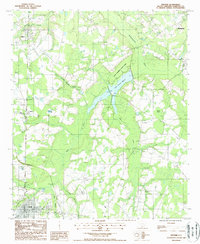
1988 Map of Gifford
USGS Topo · Published 1988About this map
Lake Warren State Park and the waters of Lake George Warren anchor this South Carolina landscape during the 1980s. The region is defined by its low-lying hydrology, where the Coosawhatchie River and its tributaries like Blood Hill Creek and Brier Creek move through a network of wetlands and bays. The transportation history of the area is visible in the network of railways and paths, including an Old RR Grade and the RR Grade near Luray, which speak to the timber and agricultural movement that shaped these small towns.
Find a feature on this map
19 named features on this map. Tap any name to fly to it.
Don’t see what you’re looking for? This feature index may not catch every label — zoom into the map to look around manually.
Map Details
Editions of this 1988 Gifford Map
This is the sole edition of this map. No revisions or reprints were ever made.
Other maps of this area

1918 · Varnville
USGS Topo · 1:62,500

1919 · Pineland
USGS Topo · 1:62,500

1919 · Shirley
USGS Topo · 1:62,500

1920 · Peeples
USGS Topo · 1:62,500

1943 · Pineland
USGS Topo · 1:62,500

1943 · Peeples
USGS Topo · 1:62,500

1943 · Shirley
USGS Topo · 1:62,500

1944 · Varnville
USGS Topo · 1:62,500

1947 · Savannah
USGS Topo · 1:250,000

1948 · Savannah
USGS Topo · 1:250,000