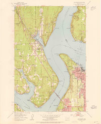
1953 Map of Gig Harbor
USGS Topo · Published 1955About this map
The maritime communities of the Puget Sound are captured in detail during the early 1950s, centering on the sheltered waters of Gig Harbor. Across The Narrows, the industrial and residential edges of Tacoma and Ruston show the significant infrastructure of the era, including the Tacoma Smelter and the Tacoma Narrows Bridge (Toll Bridge). The map provides a look at the cultural and social landmarks of the period, such as the Ft Nisqually (Restoration) within Defiance Park and the Frank Tobey Jones Home. Local life on the Kitsap Peninsula side is marked by small settlements like Artondale, Wollochet, and Harbor Heights. Transportation and community history are visible through features like the Fox Island-Sixth Avenue Ferry and the Narrows Bridge Sch (Abandoned), illustrating the shifting patterns of rural education and regional connectivity as the post-war suburban footprint expanded around the sound.
Find a feature on this map
71 named features on this map. Tap any name to fly to it.
Don’t see what you’re looking for? This feature index may not catch every label — zoom into the map to look around manually.
Map Details
Editions of this 1953 Gig Harbor Map
This is the sole edition of this map. No revisions or reprints were ever made.
Other maps of this area

1897 · Tacoma
USGS Topo · 1:125,000

1900 · Tacoma
USGS Topo · 1:125,000

1940 · Anderson Island
USGS Topo · 1:62,500

1941 · Tacoma South
USGS Topo · 1:62,500

1942 · Gig Harbor
USGS Topo · 1:62,500

1943 · Gig Harbor
USGS Topo · 1:62,500

1944 · Tacoma South
USGS Topo · 1:62,500

1948 · Anderson Island
USGS Topo · 1:62,500

1948 · Anderson Island
USGS Topo · 1:24,000

1948 · Steilacoom
USGS Topo · 1:24,000