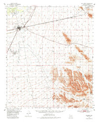
1951 Map of Gila Bend
USGS Topo · Published 1984About this map
Gila Bend serves as a critical desert junction in the early 1950s, where the Southern Pacific and Tucson Cornelia and Gila Bend railroads converge. The landscape is defined by the vital waters of the Gila River and the Gila Bend Canal, which support settlements like Sil Murk within the Gila Bend Indian Reservation. To the south and east, the desert floor rises sharply into the Maricopa Mountains and the Sand Tank Mountains, featuring landmarks such as Blue Plateau and Round Butte.
Find a feature on this map
29 named features on this map. Tap any name to fly to it.
Don’t see what you’re looking for? This feature index may not catch every label — zoom into the map to look around manually.
Map Details
Editions of this 1951 Gila Bend Map
3 editions found
Other maps of this area

1950 · Theba
USGS Topo · 1:62,500

1951 · Estrella
USGS Topo · 1:62,500

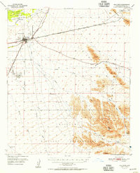
1951 · Gila Bend
USGS Topo · 1:62,500

1951 · Theba
USGS Topo · 1:62,500

1951 · Mobile
USGS Topo · 1:62,500

1951 · Cotton Center
USGS Topo · 1:62,500

1951 · Woolsey Peak
USGS Topo · 1:62,500

1953 · Ajo
USGS Topo · 1:250,000

1954 · Phoenix
USGS Topo · 1:250,000

1957 · Ajo
USGS Topo · 1:250,000