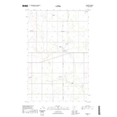
2020 Map of Gildford
USGS Topo · Published 2020About this map
Gildford serves as a concentrated center of activity in Hill County, Montana, amidst a vast agricultural landscape structured by the Public Land Survey System. The town's layout is defined by a grid of streets such as 5th St and 6th St, positioned near the intersection of Gildford Rd and local infrastructure. Just north of the main settlement lies the Gildford Hill County Cem, a vital site for genealogical research in this rural region.
Find a feature on this map
20 named features on this map. Tap any name to fly to it.
Don’t see what you’re looking for? This feature index may not catch every label — zoom into the map to look around manually.
Map Details
Editions of this 2020 Gildford Map
This is the sole edition of this map. No revisions or reprints were ever made.
Other maps of this area

1904 · Boxelder
USGS Topo · 1:62,500

1906 · Kremlin
USGS Topo · 1:62,500

1906 · Boxelder
USGS Topo · 1:62,500

1919 · Big Sandy
USGS Topo · 1:125,000

1920 · Gildford
USGS Topo · 1:125,000

1943 · Gildford
USGS Topo · 1:125,000

1954 · Shelby
USGS Topo · 1:250,000

1958 · Shelby
USGS Topo · 1:250,000
1969 · Sage Lake
USGS Topo · 1:24,000

1969 · Box Elder NW
USGS Topo · 1:24,000