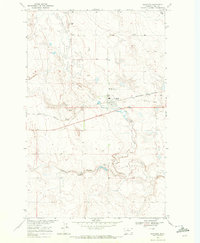
1969 Map of Gildford
USGS Topo · Published 1972About this map
Gildford sits at the heart of this North Central Montana landscape, a rail-oriented town defined by its connection to the Burlington Northern line. The map captures a moment in the late 1960s when the region's agricultural and industrial infrastructure was clearly delineated, from the numerous Gravel Pits and scattered Storage Bins to a network of local resources like the Gildford Hill County Cem and a prominent Well.
Find a feature on this map
12 named features on this map. Tap any name to fly to it.
Don’t see what you’re looking for? This feature index may not catch every label — zoom into the map to look around manually.
Map Details
Editions of this 1969 Gildford Map
This is the sole edition of this map. No revisions or reprints were ever made.
Other maps of this area

1904 · Boxelder
USGS Topo · 1:62,500

1906 · Kremlin
USGS Topo · 1:62,500

1906 · Boxelder
USGS Topo · 1:62,500

1919 · Big Sandy
USGS Topo · 1:125,000

1920 · Gildford
USGS Topo · 1:125,000

1943 · Gildford
USGS Topo · 1:125,000

1954 · Shelby
USGS Topo · 1:250,000

1958 · Shelby
USGS Topo · 1:250,000
1969 · Sage Lake
USGS Topo · 1:24,000

1969 · Box Elder NW
USGS Topo · 1:24,000