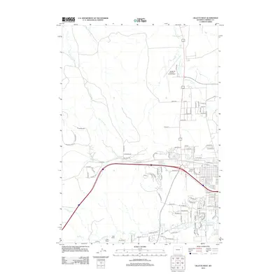
2012 Map of Gillette West
USGS Topo · Published 2012About this map
The Gillette-Campbell County Airport serves as a modern anchor in this High Plains landscape, where the northern outskirts of town meet a drainage network defined by the Little Rawhide Cr. The terrain is deeply carved by watercourses like Lone Tree Prong and Stonepile Cr, revealing the complex local hydrology. Transport infrastructure is prominent, showing the expansion of residential streets such as Peaceful Valley Dr and industrial corridors along Echeta Rd and Airport Rd. Genealogists and local historians can trace the development of outlying areas near Oluf Draw and Donkey Cr, where the 2012 road names like Wild Bronc Way and Road 3789 reflect a mix of contemporary ranching and municipal growth at the edge of the Powder River Basin.
Find a feature on this map
99 named features on this map. Tap any name to fly to it.
Don’t see what you’re looking for? This feature index may not catch every label — zoom into the map to look around manually.
Map Details
Editions of this 2012 Gillette West Map
This is the sole edition of this map. No revisions or reprints were ever made.
Other maps of this area

1954 · Gillette
USGS Topo · 1:250,000

1955 · Gillette
USGS Topo · 1:250,000

1958 · Gillette
USGS Topo · 1:250,000

1962 · Gillette
USGS Topo · 1:250,000

1971 · Gillette East
USGS Topo · 1:24,000

1971 · Oriva NW
USGS Topo · 1:24,000

1971 · Oriva
USGS Topo · 1:24,000
1971 · The Gap
USGS Topo · 1:24,000
1971 · Appel Butte
USGS Topo · 1:24,000
1971 · Gillette West
USGS Topo · 1:24,000