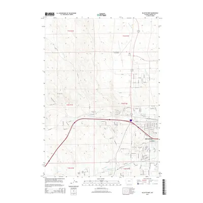
2015 Map of Gillette West
USGS Topo · Published 2015About this map
Gillette expands westward across this 2015 study, where urban development meets the high plains drainage systems of the Powder River Basin. The landscape is defined by the convergence of several seasonal waterways, including Stonepile Cr and Donkey Cr, which carve through the terrain near the Gregersen Reservoir. The city's growth is evident in the dense network of residential streets and avenues, such as Oregon Ave and Larch St, pushing toward the undulating country to the west. To the north, the Gillette-Campbell County Airport serves as a major regional landmark, while Mount Pisgah Cem sits on the eastern edge of the quadrangle. Rural tracks like McKenzie Rd and W Echeta Rd provide access to the outlying draws and prongs, illustrating the transition from a concentrated municipal hub to the open rangeland characteristic of Campbell County.
Find a feature on this map
110 named features on this map. Tap any name to fly to it.
Don’t see what you’re looking for? This feature index may not catch every label — zoom into the map to look around manually.
Map Details
Editions of this 2015 Gillette West Map
This is the sole edition of this map. No revisions or reprints were ever made.
Other maps of this area

1954 · Gillette
USGS Topo · 1:250,000

1955 · Gillette
USGS Topo · 1:250,000

1958 · Gillette
USGS Topo · 1:250,000

1962 · Gillette
USGS Topo · 1:250,000

1971 · Gillette East
USGS Topo · 1:24,000

1971 · Oriva NW
USGS Topo · 1:24,000

1971 · Oriva
USGS Topo · 1:24,000
1971 · The Gap
USGS Topo · 1:24,000
1971 · Appel Butte
USGS Topo · 1:24,000
1971 · Gillette West
USGS Topo · 1:24,000