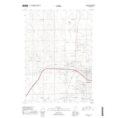
2017 Map of Gillette West
USGS Topo · Published 2017About this map
Gillette expands westward into the high plains in this modern topographic survey, showing a landscape where residential development meets the traditional ranching terrain of Campbell County. The drainage patterns of Stonepile Cr and Little Rawhide Cr provide the primary relief across the northern sections, while the southern reach is defined by the headwaters of Donkey Cr and its tributaries like Oluf 1 Draw. The northern sector is dominated by the Gillette-Campbell County Airport, a critical infrastructure point for the region. This 2017 study illustrates the transition from a structured urban grid to an expansive network of rural roads and named ways, such as McKenzie Rd and W Echeta Rd, reflecting the continued growth of this energy-sector hub in the Powder River Basin.
Find a feature on this map
113 named features on this map. Tap any name to fly to it.
Don’t see what you’re looking for? This feature index may not catch every label — zoom into the map to look around manually.
Map Details
Editions of this 2017 Gillette West Map
This is the sole edition of this map. No revisions or reprints were ever made.
Other maps of this area

1954 · Gillette
USGS Topo · 1:250,000

1955 · Gillette
USGS Topo · 1:250,000

1958 · Gillette
USGS Topo · 1:250,000

1962 · Gillette
USGS Topo · 1:250,000

1971 · Gillette East
USGS Topo · 1:24,000

1971 · Oriva NW
USGS Topo · 1:24,000

1971 · Oriva
USGS Topo · 1:24,000
1971 · The Gap
USGS Topo · 1:24,000
1971 · Appel Butte
USGS Topo · 1:24,000
1971 · Gillette West
USGS Topo · 1:24,000