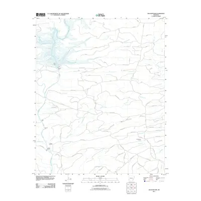
2011 Map of Gillham Dam
USGS Topo · Published 2011About this map
Gillham Dam serves as the central landmark in this 2011 survey of western Arkansas, where the Cossatot River is fed by numerous tributaries including Striklin Creek and Coon Creek. This modern cartographic record captures a landscape defined by water management and rural crossings, preserving the location of local crossing points such as Three Shoot Ford and Ladd Ford. The road network is dense with named forest and county routes like Gillham Lake Rd, reflecting the area's ongoing use for timber or recreation near the reservoir. Genealogists and local historians can pinpoint long-established sites such as the Cossatot Cemetery and Old New Hope Cemetery, alongside traditional river landmarks like Clinton Ford and Flanagan Ford, providing a clear view of how the modern infrastructure overlays older rural patterns.
Find a feature on this map
99 named features on this map. Tap any name to fly to it.
Don’t see what you’re looking for? This feature index may not catch every label — zoom into the map to look around manually.
Map Details
Editions of this 2011 Gillham Dam Map
This is the sole edition of this map. No revisions or reprints were ever made.
Other maps of this area

1913 · De Queen
USGS Topo · 1:125,000

1950 · Mcalester
USGS Topo · 1:250,000

1959 · Umpire
USGS Topo · 1:62,500

1959 · Cove
USGS Topo · 1:62,500

1962 · McAlester
USGS Topo · 1:250,000

1964 · Gillham Dam
USGS Topo · 1:24,000

1964 · Gillham
USGS Topo · 1:24,000

1965 · McAlester
USGS Topo · 1:250,000
1966 · De Queen
USGS Topo · 1:24,000
1966 · Dierks Dam
USGS Topo · 1:24,000