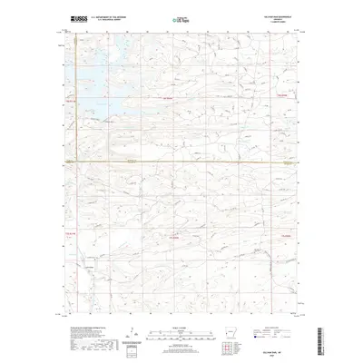
2020 Map of Gillham Dam
USGS Topo · Published 2020About this map
Cossatot River flow and the impoundment of Gillham Lake define the geography of this borderland where Polk, Howard, and Sevier counties meet. The landscape is characterized by a dense network of creek drainages, including Hunters Cr, French Cr, and Strikin Cr, which cut through the timbered terrain. This modern survey illustrates the contemporary water management infrastructure at the Gillham Dam while preserving the locations of earlier cultural landmarks. Genealogists and local historians can locate Old New Hope Cem and Cossatot Cem, alongside the crossing at Ladds Bridge. The map provides a detailed view of the forest service and county road networks, such as Forest Pvt and various numeric routes, that provide access to the various forks of Hurricane Cr and Snake Cr south of the dam.
Find a feature on this map
106 named features on this map. Tap any name to fly to it.
Don’t see what you’re looking for? This feature index may not catch every label — zoom into the map to look around manually.
Map Details
Editions of this 2020 Gillham Dam Map
This is the sole edition of this map. No revisions or reprints were ever made.
Other maps of this area

1913 · De Queen
USGS Topo · 1:125,000

1950 · Mcalester
USGS Topo · 1:250,000

1959 · Umpire
USGS Topo · 1:62,500

1959 · Cove
USGS Topo · 1:62,500

1962 · McAlester
USGS Topo · 1:250,000

1964 · Gillham Dam
USGS Topo · 1:24,000

1964 · Gillham
USGS Topo · 1:24,000

1965 · McAlester
USGS Topo · 1:250,000
1966 · De Queen
USGS Topo · 1:24,000
1966 · Dierks Dam
USGS Topo · 1:24,000