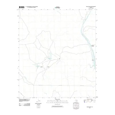
2010 Map of Gillis Ranch
USGS Topo · Published 2010About this map
The Devils River corridor dominates this interior stretch of Val Verde County, defining a landscape marked by ranching infrastructure and river crossings. Ranching legacy is anchored by the Gillis Ranch, which utilizes managed water resources including Gillis East Lake and Gillis West Lake, both held by namesake structures like the Gillis West Lake Dam. The river itself features historically significant transit points such as Rubboard Crossing and Pafford Crossing, which provided essential access across the waterway in an era before extensive highway development. The map also traces the path of Wardlaw Ranch Rd through the southern portion of the survey. Topographic detail captures the drainages of Dead Mans Creek and Evans Creek, illustrating how seasonal water flow shaped the distribution of settlements and roads in this cattle-country environment.
Find a feature on this map
11 named features on this map. Tap any name to fly to it.
Don’t see what you’re looking for? This feature index may not catch every label — zoom into the map to look around manually.
Map Details
Editions of this 2010 Gillis Ranch Map
This is the sole edition of this map. No revisions or reprints were ever made.
Other maps of this area

1941 · Feely
USGS Topo · 1:62,500

1944 · Dry Devil
USGS Topo · 1:62,500

1944 · Devils Lake
USGS Topo · 1:62,500

1944 · Baker Crossing
USGS Topo · 1:62,500

1958 · Del Rio
USGS Topo · 1:250,000

1964 · Del Rio
USGS Topo · 1:250,000

1972 · California Creek
USGS Topo · 1:24,000
1972 · Box Canyon
USGS Topo · 1:24,000
1972 · Satan Canyon
USGS Topo · 1:24,000
1972 · Gillis Ranch
USGS Topo · 1:24,000