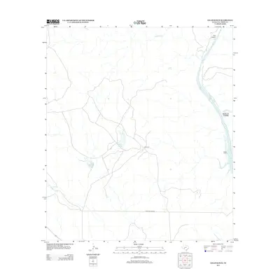
2013 Map of Gillis Ranch
USGS Topo · Published 2013About this map
Gillis Ranch serves as the focal point of this arid Val Verde County landscape, where water dictates the location of human activity. The Devils River defines the eastern boundary of this quadrangle, flanked by geographic landmarks such as Dark Canyon and Little Satan Cr. A sparse network of roads, including Wardlaw Ranch Rd, connects the interior ranch lands to the river's edge. Significant river access points like Rubboard Crossing and Pafford Crossing indicate historical transit routes through this section of the Edwards Plateau. The presence of seasonal hydrology is evidenced by Gillis E Lake and Gillis W Lake, along with drainage systems like Dead Mans Cr and Evans Cr which carve through the limestone terrain.
Find a feature on this map
12 named features on this map. Tap any name to fly to it.
Don’t see what you’re looking for? This feature index may not catch every label — zoom into the map to look around manually.
Map Details
Editions of this 2013 Gillis Ranch Map
This is the sole edition of this map. No revisions or reprints were ever made.
Other maps of this area
1941 · Feely
USGS Topo · 1:62,500
1944 · Dry Devil
USGS Topo · 1:62,500
1944 · Devils Lake
USGS Topo · 1:62,500
1944 · Baker Crossing
USGS Topo · 1:62,500
1958 · Del Rio
USGS Topo · 1:250,000
1964 · Del Rio
USGS Topo · 1:250,000
1972 · California Creek
USGS Topo · 1:24,000
1972 · Box Canyon
USGS Topo · 1:24,000
1972 · Satan Canyon
USGS Topo · 1:24,000
1972 · Gillis Ranch
USGS Topo · 1:24,000