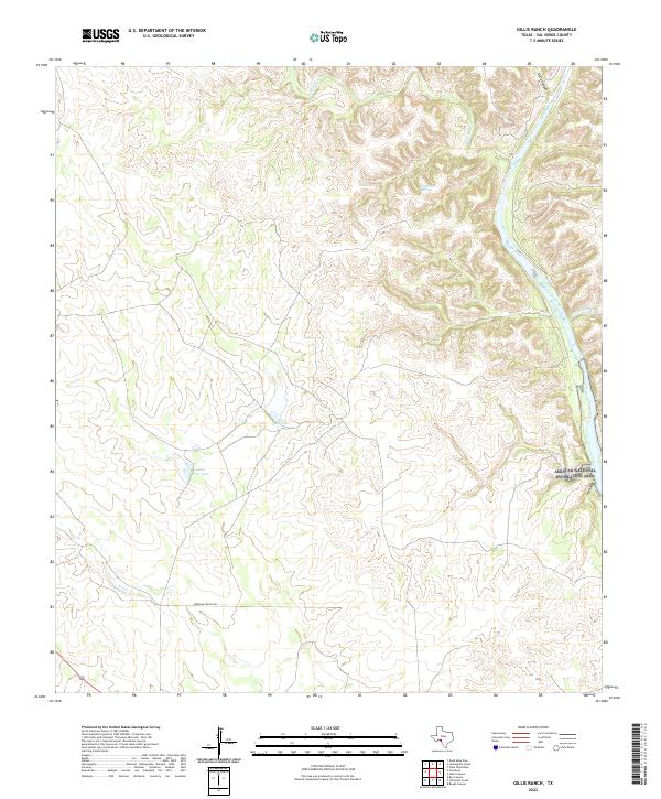
2022 Map of Gillis Ranch
USGS Topo · Published 2022About this map
The Devils River corridor in Val Verde County defines this landscape, showing a complex network of canyons and water features essential to life in this arid region. The presence of Gillis Springs and the nearby Gillis East Lake and Gillis West Lake suggests a localized focus on water management and land use within the broader ranching economy. The map illustrates the sharp topographic relief of the area, punctuated by deep incisions like Dark Canyon and the evocatively named Dead Mans Cr and Little Satan Cr. Much of the eastern portion of the sheet is protected as part of the Amistad National Recreation Area, reflecting the modern balance between conservation and historic ranching access, represented here by the lone track of Wardlaw Ranch Rd.
Find a feature on this map
10 named features on this map. Tap any name to fly to it.
Don’t see what you’re looking for? This feature index may not catch every label — zoom into the map to look around manually.
Map Details
Editions of this 2022 Gillis Ranch Map
This is the sole edition of this map. No revisions or reprints were ever made.
Other maps of this area

1941 · Feely
USGS Topo · 1:62,500

1944 · Dry Devil
USGS Topo · 1:62,500

1944 · Devils Lake
USGS Topo · 1:62,500

1944 · Baker Crossing
USGS Topo · 1:62,500

1958 · Del Rio
USGS Topo · 1:250,000

1964 · Del Rio
USGS Topo · 1:250,000

1972 · California Creek
USGS Topo · 1:24,000
1972 · Box Canyon
USGS Topo · 1:24,000
1972 · Satan Canyon
USGS Topo · 1:24,000
1972 · Gillis Ranch
USGS Topo · 1:24,000