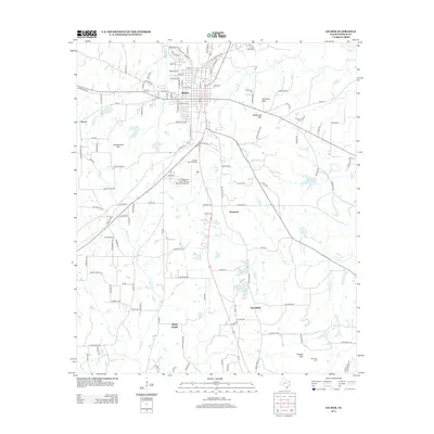
2013 Map of Gilmer
USGS Topo · Published 2013About this map
Gilmer serves as the focal point of this East Texas survey, showing a well-established street grid and residential development near the center of Upshur County. The landscape is defined by several low-lying peaks, including Underwood Mtn, Simpson Mtn, and McDonald Mtn, which rise above the surrounding creek drainages. To the south, aviation facilities at Fox Stephens Field - Gilmer Municipal Airport occupy the level ground between Brooks Cr and the neighborhood of Piedmont. Local history is preserved in sites like the Reynolds Cem near Tidwell Mtn and the community surrounding Mings Chapel. The map reveals a complex network of waterways, including Stillhouse Cr and Clear Cr, alongside small-scale agriculture and rural settlements like Pattonfield and Enoch. Modern infrastructure is visible through the systematic naming of roads such as Cherokee Trce and Old Coffeeville Rd.
Find a feature on this map
134 named features on this map. Tap any name to fly to it.
Don’t see what you’re looking for? This feature index may not catch every label — zoom into the map to look around manually.
Map Details
Editions of this 2013 Gilmer Map
This is the sole edition of this map. No revisions or reprints were ever made.
Other maps of this area

1956 · Tyler
USGS Topo · 1:250,000
1960 · Big Sandy
USGS Topo · 1:24,000
1960 · Pritchett
USGS Topo · 1:24,000
1960 · Bettie
USGS Topo · 1:24,000
1960 · White Oak
USGS Topo · 1:24,000
1960 · Gilmer
USGS Topo · 1:24,000
1960 · Thomas
USGS Topo · 1:24,000
1960 · Coffeeville
USGS Topo · 1:24,000
1960 · Glenwood
USGS Topo · 1:24,000
1960 · Gladewater
USGS Topo · 1:24,000