
1960 Map of Thomas
USGS Topo · Published 1962About this map
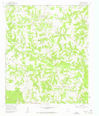
Little Cypress Creek and its many tributaries, including Caney Creek, Prairie Creek, and Johnson Branch, carve through this landscape of the Post Oak Savannah. Small agrarian settlements and church-centered communities define the region, with Thomas situated near the northern edge and Rosewood and Harmony anchoring the southern border. The map illustrates a rural Texas social fabric built around local institutions like Harmony Sch and several country churches, including Soules Chapel and Enon Ch. One of the most distinctive markers of the area's history is the Cherokee Trace, an early road that cuts across the eastern portion of the quadrangle. Genealogists will find particular value in the documentation of burial sites like Simpsonville Cem and Grice Cem, alongside family-named water features such as Williams Branch and Hamberlin Branch.
Find a feature on this map
37 named features on this map. Tap any name to fly to it.
Don’t see what you’re looking for? This feature index may not catch every label — zoom into the map to look around manually.
Map Details
Editions of this 1960 Thomas Map
3 editions found
Other maps of this area

1956 · Tyler
USGS Topo · 1:250,000

1960 · Shady Grove
USGS Topo · 1:24,000

1960 · Pritchett
USGS Topo · 1:24,000

1960 · Bettie
USGS Topo · 1:24,000

1960 · Gilmer
USGS Topo · 1:24,000

1960 · Newsome
USGS Topo · 1:24,000

1960 · Leesburg
USGS Topo · 1:24,000

1960 · Rhonesboro
USGS Topo · 1:24,000

1960 · Pittsburg
USGS Topo · 1:24,000

1984 · Tyler
USGS Topo · 1:250,000